


Get In Touch
 |
Unit No. 1403, 14th Floor, Negin Reza tower, Ashrafi Esfahani Expy, Tehran, Iran. +98 21 4403 1818 +98 21 4406 3628 This email address is being protected from spambots. You need JavaScript enabled to view it. |

Super User
Kushk Lead and Zinc mine situated at 165 km far from east of Yazd and 45 km of northeast of Bafgh Township at Lut desert margin. This mine use underground method in its extraction and certain Lead and Zinc reserves of the mine has been estimated 2997000 tons with 14 % carat.

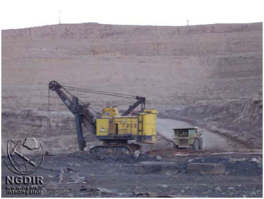
mine installations

mine underground tunnel

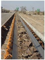
Picture of ore carrier wagons

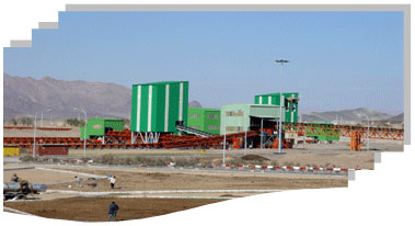
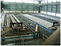
The lead and zinc beneficiation plant at Dandi with a capacity of about 140 tons per hour is located 100 km southwest of Zanjan town. Oxidized lead- and zinc ore from the Anguran mine (situated at a distance of 20km from the plant) is used as the feed for this plant. The primary minerals of this mine are cerussite and smithsonite. The plant has been designed to handle two types of feeds i.e. low- and high grade zinc ores. The plant has been equipped and installed from1973-1979. The high grade ore contains 10% lead and 35% zinc while the low grade ore averages 7% lead and 22% zinc. The normal products of the plant include lead concentrate grading 60% lead, zinc concentrate with 38% zinc and a calcined zinc concentrate with 52% zinc. This plant includes the following sections: rock crushing, HMS, milling, filtration and calcination. If the feed is of the low-grade type, it is first upgraded by HMS cyclones and the concentrate obtained is introduced along with the high grade feed into the milling circuit and subsequently concentrated in the flotation unit. Material <2mm in size which is not introduced into the HMS circuit, is milled and added to the low grade flotation route. Finally, after the rougher, cleaner and scavenger stages of the lead flotation route, a concentrate with 60% lead is obtained and the corresponding tailing is dewatered and sent to the zinc concentrate stockpile. A part of the zinc concentrate is sent to the calcination unit to obtain a calcined product containing 52% zinc.
The Sangan Fe deposit is located about 18 km NE of Sangan town in Central East Iran (Khorasan Province) and about 500 km NNE of Bafq. The Sangan deposit contains ~500 Mt of high-grade Fe-oxide reserves and is divided into the east, west and central ore bodies. The ore is hosted by carbonates associated with felsic volcanic and intrusive rocks including rhyolite, trachyte, dacite, andesite, granite and monzonite. The granites have a calc-alkaline geochemical signature. The main ore mineral is magnetite with minor hematite, pyrite, chalcopyrite and pyrrhotite. Two types of skarn have been recognised; a Ca-skarn containing garnet, clinopyroxene, calcite, quartz, amphibole, epidote, scapolite and dolomite bearing assemblages and Mg-skarn with forsterite, phlogopite, serpentine, clinochlore, amphibole, talc, magnesite, chlorite, calcite and sulphides (Ebrahimizadeh, 1995). Bagherian Kalat (1996) suggest that the main mineralizing stage is associated with hydrothermal activities that followed the primary stage of skarn development. Giere and Mohammadi (1977) describe the ore body as pipe-like, with signs of an explosive emplacement. Kermani and Forster (1991) proposed that the ore at Sangan crystallised from a Fe-rich magma.(JAMI, 2005)

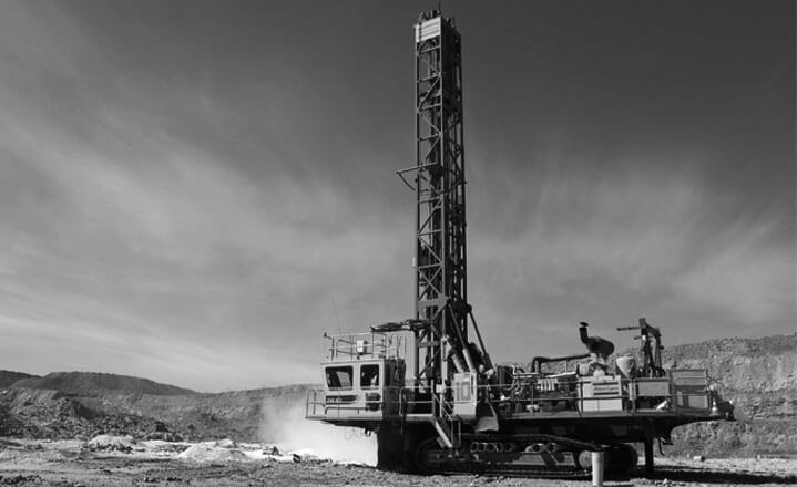
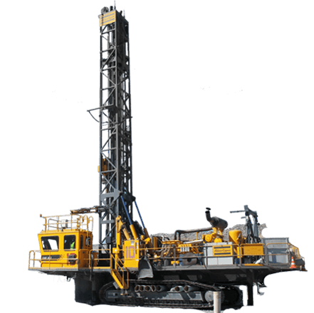
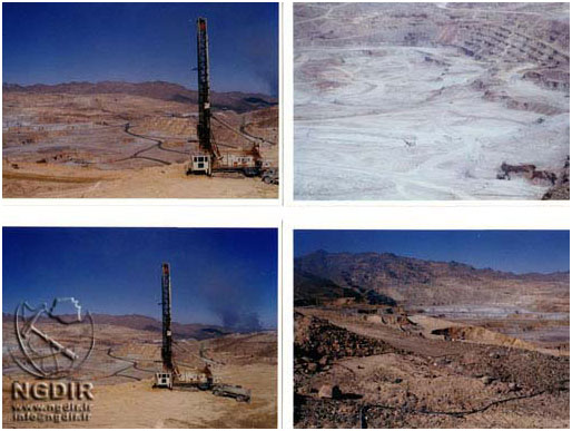
Wagon drill

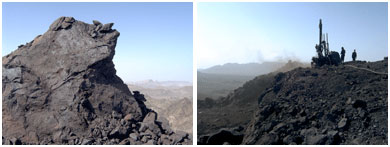
View of Sangan mine bench face

Picture of Sangan mine bench face

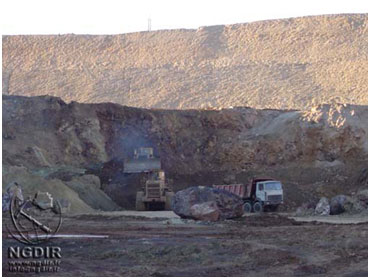
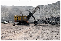
View of extraction activities by exploration equip

View of Sangan mine
GolGohar Iron Ore Co is located in southern Iran, 50 km from Sirjan, in southwest of Kerman Province (latitude 29°7′N and longitude 55°19′E) surrounded by mountains over 2500 m high. In 1969, GolGohar Iron Ore deposits were discovered by Iran Barite Company. GolGohar follows a mining tradition in this region which dates back 900 years.
GolGohar Mines contain 6 ore bodies spread over an area of 40 square km. The total deposits of iron ore in the region are estimated to be over 1.135 billion tons. The major ore body has a deposit of more than 650 million tons. GolGohar is connected to the Trans-Iranian Railway through the Tehran-Bandar Abbas line At GolGohar, 6 million tons per year of concentrate is produced through crushing, dring and wet grinding, and magnetic separation methods using low intensity magnetic separators. Dry magnetic separation extracts 65% of the final product and the rest is obtained by a process of wet magnetic separation.
A concentrate production line to process an additional 2.5 million tons per year of is under construction and will be in operation in the near future. The construction of a 5 million ton/year pelletizing unit next to existing installations was recently completed and is currently commencing production.
Petrographic and geochemical studies of metaplite and amphibolite units show that those were marl and shale sedimentary rocks that are metamorphed and mylonitization to mid- amphibolite facies during early Cimmerian orogeny and no relationship with deposit genesis. Iron ore mineralization has happened simultaneously and after Gol-Gohar complex deposition and pyrite mineralization after creating iron oxide. Talc, serpentine and clinochlore are gangue main minerals in association with magnetite. Serpentine of olivine metasomatism, talc of serpentine alteration and clinochlore has been created during retrograde changes of reaction aluminum-bring fluids with the serpentine. Comparison of main, trace and rare-earth elements of Gol-Gohar iron ore with other iron deposit of the world and Iran shows it is similarities with the volcano-sedimenter and skarn iron type and most diagrams normalized REE shows same trend with deposits as magmatic fluids origin. Carbon and oxygen isotope investigation on deposit breakers carbonate veins that have often dolomitic composition shows for thier low temperature hydrothermal origin. Acording to the results of these studies is argued that Gol-Gohar iron ore has been formed during two stages as follows: first stage- the iron-bring fluids enter to sedimentary basin and deposition of iron ore to form of volcano-sedimenter type, simultaneous with Gol-Gohar complex. The second stage-during Neotethys ocean subduction and early Cimmerian orogenic operation, all set of first stage is affected amphibolite facies metamorphism. Pay attention to granite intrusions existence in the South of Gol-Gohar ore deposit and also in drilling core within ore body seems along with orogenic and mass intrusive enter has lead to iron ore re-creating or iron-bring fluids re-rotation in dolomitic units and Mg-skarn (olivine, talc and serpentine) formation. Finally, green schist retrograde facies has effect of the region total and has been causing the formation of chlorite and epidote minerals in Gol-Gohar complex and clinochlor in iron ore.
A brief statistical guide to the GolGohar area:
- Height above sea level : 1750 m
- Average annual rainfall : 120 mm
- Highest temperature recorded: : + 40 degree Celsius
- Lowest temperature recorded : - 16 degree Celsius
- Max. Wind Speed : 65 km/h
- Average humidity: +30
As of June 21,2010 the company is owned by the following share holders:
- Omid Investment Management Corporation : 39.02%
- Mines & Metals Development Investment Company : 23.75%
- Mobarakeh Steel Company : 6.46%
- Civil Servants Pension Fund : 2.80%
- Mehregan Investment Co. : 3.75%
- Oil Pension Fund Investment Co. : 3.62%
- Others : 20.6%
- Total Shares : 100%
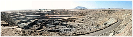
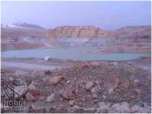
Extraction activities in the Gole-Gohar mine
A View of Gole-Gohar mine bench face
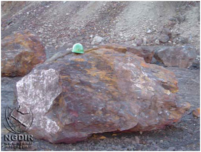
A Picture of Gole-Gohar mine ore
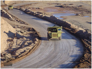
Ore transport by mine machinery
The origin of the Proterozoic Choghart iron oxide deposit in the Bafq mining district of Central Iran has been the subject of a long-standing dispute. Some authors believe that it was formed from magma, while others suggest metasomatic replacement of preexisting rocks. The present study on the basis of new oxygen isotope, REE and geochemical data concludes that neither of these two hypotheses can alone explain the formation of Choghart deposit. Instead, it is suggested that the separation of an iron oxide melt and the ensuing hydrothermal processes dominated by alkali metasomatism were both involved to different degrees in the formation of Choghart and other similar deposits in Central Iran.
MOORE & MODABBERI.
Choghart Iron Deposite is one of the largest iron ore mines of Iran, which is located in the northeast of Bafgh-Yazd. The minable reserve is more than 170 million tons. This mine is extracted by surface mining method.
Mining operations usually include the five stages of drilling, blasting, loading, hauling and crushing. Loading and Transporting is done with truck-Shovel system.
Drilling and blasting operations are so important, because of some reasons such as: complex discontinuity system existence, the rock type variations and the water bearing beds.
- Choghart Mine Characteristics:
- Shape and Size of pit: Ellipse (840m Long Diagonal & 640m Width Diagonal)
- Stripping ratio: 0.85
- Highest Level: 1140 m
- Pit Depth: 327.5 m
- Overall Slope Angle: 55 degree
- Bench Height: 10 m (from 1140 to 1100 level), 12.5 m (from 1100 to 812.5 level)
- Shovel capacity: 7.6 m3
- Truck capacity: 85 ton
- Ore Specification: ( Fe: 66% & P: 0.12% )
- Chaghart Expansion Project
Objects of this Choghart Expansion Project, which has been started since 1989, are:
- To secure the supply of 3 Mt/y of suitable DSO feed (Direct Shipping Ore) for Blast Furnace
- To produce 3.2 Mt/y Iron concentrate as feed to Agglomeration Plant.
Due to existence of differences between the mined ores from Choghart and Sechahoun mines, two separate processing lines have been considered.
- Choghart Beneficiation Plant
A 3.2 Mt/y fine concentration beneficiation plant consisting of two independent process lines, as below:
- Choghart Process Line, with the feed capacity of 2.3 Mt/y produce 1.6 Mt/y fine concentrate
- Choghart production line
The mined low grade high phosphorous Choghart Iron Ore rocks of about 1000 mm size are crushed to 300mm by a primary jaw crusher.
The crushed ore is then transferred to the stockpiling and reclamation area for mixing and homogenizing. The stockpiling is carried out by a stocker. Then, using reclaimer and a conveyor belt, the stockpiled crusherd ore is delivered to a 2000 tons bin, where it is fed to Autogenous (AG) mill by a vibrating feeder.
The AG mill is in closed circuit with a vibrating screen with 1 mm aperture. The screen oversize returns to the AG mill as recirculating load and the undersize material is fed to the low intensity magnetic separators (LIMS), which consists of two separation stages (Rougher and Cleaner).The rougher concentrate is fed to the cleaner separators. Then the cleaner concentrate is being dewatered by pumping it to the filteration section. The tailing from rougher and cleaner stages is pumped to a hydrocyclone for adjusting its solid content (dewatering), and then it is pumped to scavenger magnetite separators for recovery of its Iron Content. The scavenger concentrate is also being dewatering by filteration. The obtained Iron Ore concentrates are transferred from filteration section to stockpiling area for storage by belt conveyors. And from there, they will be delivered to the loading station.
- Se-Chahoun production line
The mined low grade high phosphorous Choghart Iron Ore rocks of about 1000 mm size are crushed to 300mm by a primary jaw crusher. The crushed ore is then transferred to the stockpiling and reclamation area for mixing and homogenizing. The stockpiling is carried out by a stocker. Then, using reclaimer and a conveyor belt, the stockpiled crusherd ore is delivered to a 2000 tons bin, where it is fed to Autogenous (AG) mill by a vibrating feeder.
The AG mill is in closed circuit with a vibrating screen with 1 mm aperture. The screen oversize returns to the AG mill as recirculating load and the undersize material is fed to the low intensity magnetic separators (LIMS), which consists of two separation stages (Rougher and Cleaner). The rougher concentrate is fed to the cleaner separators. Then the cleaner concentrate is being dewatered by pumping it to the filteration section.
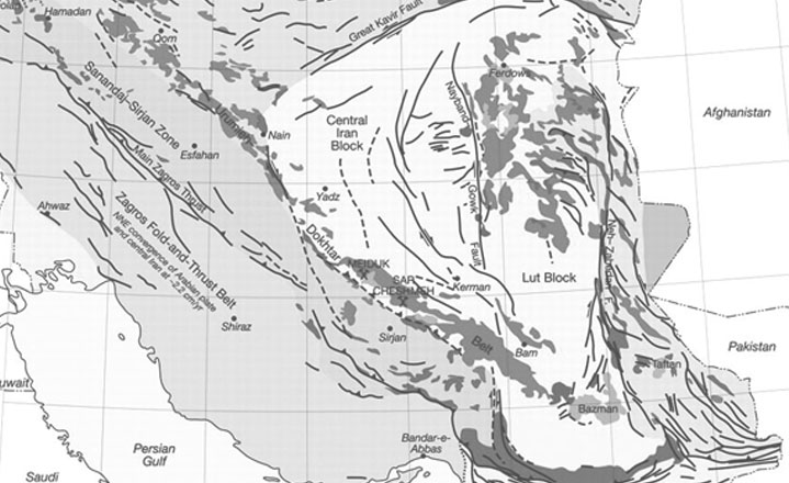
The Bafq metallogenic province hosts major (1.8 Gt) Kiruna-type, sulphide-poor REE-apatite-magnetite (±hematite) deposits that are transitional to apatite-rich rocks, called “apatitites”. The deposits are hosted by volcanosedimentarysequences as well as individual volcanic rocks of dominantly rhyolite-rhyodacite composition that are part of an Early Cambrian volcanism within the Kashmar Kerman magmatic arc in East-Central Iran. The felsic volcanism is part of a felsic-mafic bimodal volcanism of alkaline character with minor andesites and rare undersaturated rocks (nephelinite-basanite) that was followed by a regional, alkali (sodic and potassic) metasomatism, formation of albiterich rocks (albitites), apatite-Fe oxide mineralization, and swarms of late diabase dykes. Multistage metasomatism resulted in the formation of synvolcanic-synsedimentary to synsedimentary epigenetic, and post-volcanic epigenetic mineralization. The ore fluids evolved from an anhydrous paragenetic association consisting of LREE-F(-Cl±OH)-apatite and monazite ± Ca-rich pyroxene, actinolite or chlorite, ±quartz, magnetite(±hematite) ± REE-Ca-rich garnet. Multistage Actinolite is the most common ore-related alteration and formed instead of pyroxene during the early-stage at lower temperatures. Chlorite formed instead of actinolite at lower temperatures. The late-stage fluids were enriched in CO2, SiO2 and HREE and formed calcite, quartz, monazite2, apatite2, allanite, and HREE minerals xenotime, bastnaesite, syncheysite, and britholite. Minor, post-oxide pyrite±chalcopyrite was followed by talc alteration, rutile, Sr-barite, and Ca-thorianite, and by chloritization and sericitization. Anhydrite ±fluorite ±Sr-barite formed with autigenic quartz and feldspars in sedimentary ores. Similar radiometric ages of the ore-related apatite, monazite, and the host rhyolites (525–539 Ma) confirms that the mineralization was coeval with the Early Cambrian high level magmatism, suggesting a direct relationship between the magma generation and the mineralization. Ore-related, large scale metasomatism within the Bafq structural zone, and the association with the bimodal volcanism with alkaline character and an alkali metasomatism indicate a tectonomagmatic control on the mineralization that was probably related to a short lived rifting stage in the Early Cambrian. In the apparent absence of Cu-Au deposits, the Bafq region can be referred as an IOA (Iron Oxide Apatite) metallogenic province.DALIRAN et al., 2010 The Bafq mining district contains >2,000 Mt of high-grade Fe ore (NISCO, 1980), which places it among the largest non-BIF type Fe ore districts of the world. This region has attracted geologists for nearly a century due to its complexity and valuable ore deposits. The Bafq mining district contains significant bodies of magnetite mineralization as reflected by 34 major magnetic targets and several non-Fe systems containingPb and Zn, Mn, U, P and REE. The Fe-oxide deposits of the Bafq region mainly consist of magnetite-hematiteapatite and host by Cambrian volcano-sedimentary sequence (also known as Saghand Formation) associated with number of felsic and mafic intrusions. These ore bodies are commonly associated with pervasively altered rhyolitic tuffs and sandstones. The origin of the Bafq Fe deposits is the subject of a long-standing debate. Among the geological and exploration reports on the region were those of Stahl (1911); Bohne (1928, 1929); Baier (1940); Kumel (1941); Diehl (1944); Walther and Kursten (1958); Venzlaff et al. (1961); Molly (1964) and Iwao and Zahedi (1966). Huckriede et al. (1962) worked on the geology of the Kerman–Bafq region and attempted to classify its Fe ores. The National Iranian Steel Corporation (NISCO) initiated several exploration projects. The results of these investigations were compiled in a series of internal reports. These investigations were oriented toward documenting exploration of the ore field by geophysical exploration and drilling. During these programs over 80 magnetic anomalies were discovered and many of these were subsequently drilled. Based on the information acquired from these works the style of mineralization and the geological setting have been documented by geologists of National Iranian Iron and Steel Corporation. Most of the early authors proposed a metamorphic origin for the Bafq Fe-apatite deposits, although some geologists who mainly worked on the NISCO projects proposed a metasomatic origin involving metamorphism, volcanic and intrusive activity. Williams and Houshmand-zadeh (1966) proposed a magmatic origin for the Choghart deposit and compared it with the Kiruna Fe ore deposits. Investigators supporting an immiscible liquid magmatic model of formation included Forster and Borumandi (1971) and Forster and Jafarzadeh (1984) who reported magnetite lava flows and magnetite-bearing pyroclastic rocks at Chador Malu and suggested a carbonatitic affinity for the Fe-oxide melt (a theme amplified in the account of the Bafq district magnetite–apatite deposits by Forster and Jafarzadeh, 1994). Jafarzadeh (1981) interpretedthe Chador Malu deposit as an explosive vent filled with magnetite melt. Samani (1988a)classified mineralisation at the Choghart mine and at anomalies 20 and 26 as being of magnetite-carbonatite type. Darvishzadeh (1983) and Darvishzadeh et al. (1996) investigated the mineralogical and geochemical characteristics of the Esfordi Fe–P deposit and noted the alkaline affinity of the igneous rocks, the presence of apatite-rich veins, the size and shape of the apatite crystals and the carbonate-rich matrix. Based on the mineralogical association of magnetite, apatite and carbonate it was concluded that there was a relationship between carbonatitic magmatism and mineralisation, although no situ carbonatites were found at Esfordi. Haghipour (1977) wrote a geological and petrological report on the stratigraphic correlation of the Bafq host rocks. He had previously suggested a close relationship between Fe ore deposits and metasomatic metamorphism in some deposits but a volcanogenic or syngenetic origin in other deposits. Similarly, Momenzadeh (1978, 1982, 1986) proposed a syngenetic submarine volcanogenic origin for Bafq region deposits based on their massive, lenticular, banded and lens-like morphology, their development within a specific lithostratigraphic unit and relation to nearby stratified Mn and Pb deposits. Daliran (1990, 1999, 2002) also concluded that hydrothermal fluids played a prominent role in the evolution of the Bafq magnetite–apatite deposits. The significance of some of this work in relation to the Esfordi Fe–P system, particularly that of Daliran (1990, 2002) and Forster and Jafarzadeh (1994) is canvassed in the discussion and conclusion chapter of this thesis.(JAMI, 2005)
Mineral Reserved in Bafgh Region
During Infracambrian, some geological activities shaped the Bafgh Volcano Sedimentary Basin. According to these activities, 3 geological iron ore deposits were formed, which are called Bafgh blocks, such as Zarand, Saghand and Robat Poshteh Badam. Potential of Bafgh deposits have been known for a long times, and there are old mine working indicating that some ore was extracted in ancient times. For the first time in 1897 a German geologist (Stahl) identified these deposits and made the geology spot mapping. There are sufficient quantities of valuable minerals such as: Iron Ore, Mg bearing Iron Ore, Apatite, Lead and Zinc in this region. The important minable ore reserves are located at Choghart, Se-Chahoun, Chahgaz, Lakk-E-Siah and North Anomaly
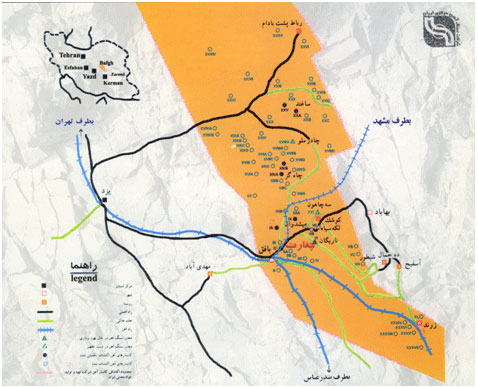
Distribution Map of Bafgh Area Iron Ore Deposits
|
||||||||||||
|
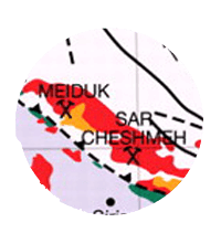
Maiduk copper mine has the distance 42 km to shahr-e-babak city in Kerman province,is located in 132 km of north west of Sar-cheshme copper mine and in mountainous condition with average altitude about 2848 m.

Weather of the area is cold in winter and moderate in summer. Maximim of temperature is 35 ° in summer and minimum is about -15 ° in winter. Maximum of rainfall is about 250 mm annually.
This area is part of the Dokhtar-Orumieh belt that is extended from west to south east of Iran. This mine was used as copper and turquoise mine.
The systematic exploration operation has been done by association of Iranian and foreign companies.
Ore in Maiduk is fungi-form with 350*400 m dimensions that it's upper part of consists of oxide-zone (malachite and azurite mineral) and supergene-zone (mostly culcosite ) Based on exploration done on this project deposit of the mine is estimated to be 170 million tons with average grade 0.83% copper. In last design 144 million tons ore with average grade 0.85% will be mined in 29 years.
Maiduk will mined with open-pit method and wests will carried to dump in around valleys. w/o is 2.4 and overburden is 350 million tons. Annual ore production is 5 million tons. Technical-economical studies done from 1968 to 1994 and primal operation such as road building, power, welfare and services foundations, concentrating factory, dam construction and mine started in 2005.
Client of this project is NICICO-Maiduk copper project. Mobin since 1993 is active in this mine as overburden removal contractor. This company has excavated 113 Million tons from 1993 to 2006 in this mine.


The Sungun copper mine is located in East Azarbaijan, Iran, in Varzaqan county, 75km north west of the provincial town ofAhar. It is the most important geologic and industrial feature in the area and is the largest open-cast copper mine in Iran and is in the primary stages of extraction.
The reserves are estimated to be as much as 995 million tons of copper ore. The ore is processed directly at a concentration plant at the mine. The capacity of the concentration plant is 170,000 tons of copper concentrates, with plans to expand to 300,000 tons.
Sarcheshmehis a large open cast copper mine in the Kerman Province of Iran, considered to be the second largest copper deposit worldwide. Also containing substantial amounts of molybdenum, gold and other rare metals.
The Sarcheshmeh Copper Complex is located 65 km southwest of Kerman and 50 km south of Rafsanjan. The region's altitude averages about 2600m, the highest spot of which approximates 3000m. Sarcheshmeh ore bodies, situated in the central part of Zagros ranges, consist of folded and faulted early tertiary volcano-sedimentary rocks.
Production units of Sarcheshmeh Copper Complex involve the mine itself, concentrator, smelter, refinery, foundries and leaching.
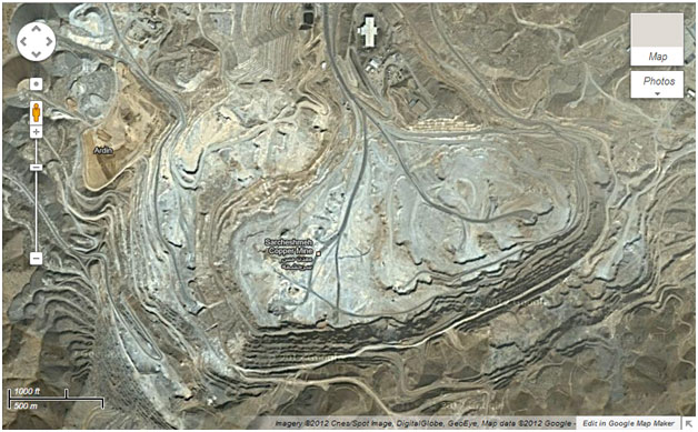
Accoring to investigation rendered,Iran is located on world copper belt starting from southeasst to northwest of Iran and Azarbaijan. Porphyry copper deposit of Sarcheshmeh is one of the largest of its kind in the world.
Sarcheshmeh copper deposit is situated at 160 Km Southwest of Kerman, 50 Km South of Rafsanjan and at the average altitude of 2,600 Meters and maximum altitude of 3,000 meters. It is located at central Zagros mountain range and is composed of stratified, sedimentary and volcanic rocks and faults pertaining to third geological era. Total Sarcheshmeh ore reserve is about 1.2 billion tons of sulfide ore at the grade of 0.7% Cu.
In 1972(1351H.), Sarcheshmeh Copper Mines Joint Stock Co of Kerman was established; and, later, in 1976(1355H.), it was renamed as National Iranian Copper Industries Co to involve all copper mines operations throughout the country. This company has numerous responsibilities to do including extraction and utilization of copper mines, production of copper concentrates and manufacturing copper products such as cathodes, slabs, billets and 8mm wire rods. Sarcheshmeh and Miduk mines in Kerman province and Sunegoon mine in eastern Azarbaiejan province are of the most significant copper mines in the country.
National Iranian Copper Industries Company (NICICO) is involved in exploration, excavation and operation of copper mines in Iran. The company's smelter has an annual production capacity of 145,000 tons of anode copper. The company owns the Sarcheshmeh copper deposit is located in southern Iran, about 65 Km south-east of Rafsanjan. It has a total reserve of 1,200,000,000 MT with an average grade of 0.70 % Cu. Sarcheshmeh porphyry (Granodiorite stock) and peripheral Andesitic volcanics are well mineralized, these series is cutted with post mineralization dykes.
NICICO also owns the Miduk and Sarcheshmeh mines which have proven reserves of 83,830,000 t and 826,500,000 respectively. Miduk produces 5,000,000 t and Sarcheshmeh 14,000,000 t of copper per annum. The Soungoun Ahar mine produces 7,000,000 t of scarn copper grade (0/5 %).
Sarcheshmeh Copper mine located in 160 km of southwest of Kerman and 50 km of south of Rafsanjan. Geological reserve of mine has been estimated over than one milliard and two hundred million tons sulfurous copper ore deposit with 70 % average carat. Additional minerals such molybdenum, gold and silver were found in mine too.
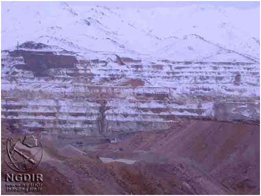
A View of Sarcheshmeh copper mine
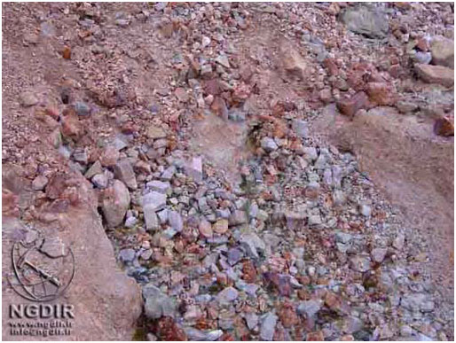
A Sample of Sarcheshmeh copper ore
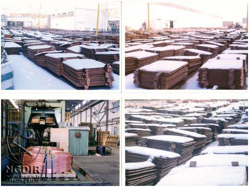
Copper slabs store
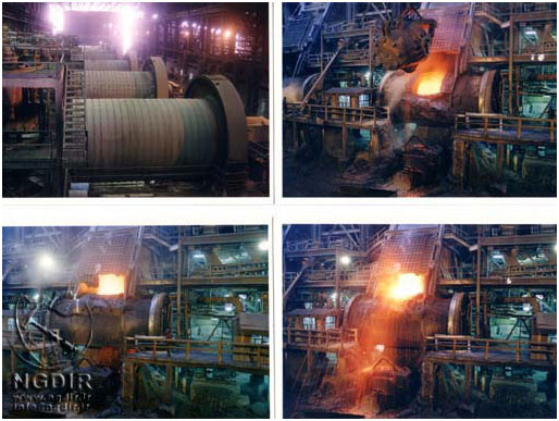
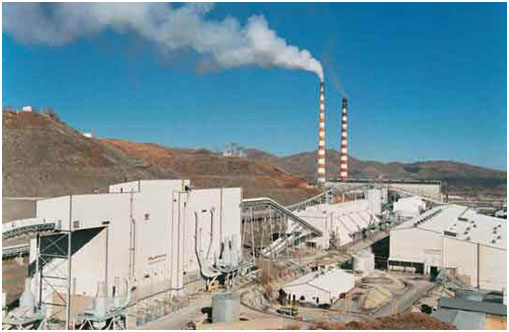
Sarcheshmeh copper mine smelt facility
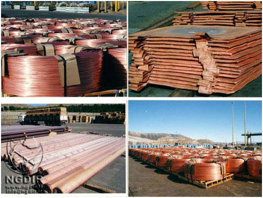
Sarcheshmeh copper company products
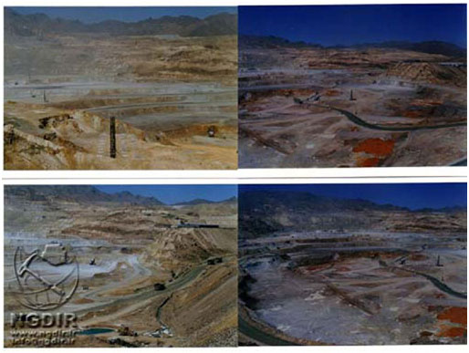
A View of wagon drill and Sarcheshmeh copper mine
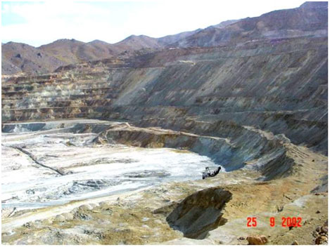
A View of Sarcheshmeh copper pit
|
Grade |
Ore (M.T) |
Country |
Rank |
|
0.73 |
22011 |
Chile |
1 |
|
0.49 |
14511 |
Peru |
2 |
|
0.39 |
8276 |
Mexic |
3 |
|
0.31 |
10128 |
USA |
4 |
|
0.89 |
3367 |
Indonesia |
5 |
|
2.08 |
1195 |
Poland |
6 |
|
0.79 |
2604 |
Mongolia |
7 |
|
0.58 |
3307 |
Australia |
8 |
|
0.56 |
3289 |
Iran |
9 |
|
0.6 |
2876 |
Kazakhstan |
10 |
|
1.66 |
881 |
Russia |
11 |
|
2.55 |
571 |
Congo |
12 |
|
0.68 |
1838 |
Brazil |
13 |
|
0.49 |
1825 |
Canada |
14 |
|
1.22 |
656 |
Zambia |
15 |
|
0.53 |
1200 |
China |
16 |
|
0.63 |
15978 |
Others |
17 |