
The major part of Iran is occupied by a moderately elevated interior basin bounded by highmountain systems along its N and SW margins. Along its E border, lower but rugged mountains provide a link between the N and S mountain systems. Within the interior basin of Iran. Several lesser chains enclose extensive deserts. Plains and playas. The N chain, the Alborz (Elburz), represents a N branch of the Alpine-Himalayan orogenic system and runs for a distance of 960 km. separating the Caspian Lowland from the Central Iran Plateau. Ranging in width from 70 to 130km. with many summits from 3600 to 4800 m in altitude, the Alborz culminates in the 5670 m volcano Mount Damavand.
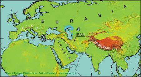
The South branch of the Alpine- Himalayan orogenic belt is occupied by the Zagros and Makran ranges extending from the Turkish border to the SE for 1600 km to the Strait of Hormoz at the month of the Persian Gulf The South branch continues in the E with the Makran ranges. The Zagros belt comprises a classical series of parallel ridges and valleys. They Culminate in Zard –Kuh (4548m). Deep dissection, tight folding and overthrust structures have created a very rugged topography in High Zagros (Zagros Thrust Zone).
Closed to the East margin of Iran,a N-S trending range provides a link between the Alborz and Zagros ranges; it extends from South of Mashhad through Zahedan and joins the Zagros-Makran trend East of Iranshahr. These mountains are narrowest and lowest in the center, where they are only 80 km wide and the ridge crests do not exceed 2000 m. South of Zahedan, Mount Taftan, a volcanic cone, reaches 4061 m.
Between the bounding ranges, the central high plateau is a major feature of Iran. It is a territory of depressions, low rises,playas,dune fields, broad alluvial fans, and isolated mountain chains.The drainage in internal, feeding several large basins, including the Lake Urumiyeh (NW Iran), Darya –ye- Namak (130 km s of Tehran), kavkhuni (SE of Esfahan),and Jaz Murain (SE Iran) depressions.
The Persian Gulf, a main artery of commerce with more than 60% of the world oil trade, is a shallow epicontinental sea, which covers the Arabian shelf platform with water depths ofless than 100 m (mainly 60 m). The smaller offshore islands E of 54; E meridian are Infracambrain –Cambrian Hormoz salt plugs, partly fringed by Neogene clastic and marine deposits and by recent coral reefs.The larger islands near the coast, Lavan, Hendurabi, kish and Qeshm,are gentle anticlines of the folded belt of the zagros system. The strait of Hormoz, 40 to 50 km wide,links the Persian Gulf with the deeper water of the Gulf of Oman.
The climate of NW Iran is more humid and cooler than of the rest of the country. Total precipitation is sufficient for dry-farming wheat agriculture in Azarbaijan.The Alborz Range forms the hydrological and climatic divide between the Caspian Depression and the Central Iranian plateau.The central Iranian Plateau has a continental desert climate with hot summers and moderately cold winters. In the interior basin, annual rainfall is less than 100 mm. SE Iran has a hot and dry climate, locally modified by the higher mountains and by the sea.Annual precipitation is below 100 mm in the Sistan and Juz Murian depressions and less than 50 mm in the Lut Depression. The Lut desert is swept by hot, desiccating winds in spring and summer which originate from the surrounding mountain range and are heated by adiabatic compression. This leads to probably the world's highest summer temperatures in the Central Lut Desert (above 50; C). Mean annual temperature differences are above 40; C and extremes are as low as 10; C in winter and as high as 60; C in summer. The climate of SW Iran is determined by the position in the global N dry belt and modified by the W wind drift from the Mediterranean area in late winter and spring. during which the main precipitation occurs.